INTRODUCTION
In 2013, an unknown ground layout was
discovered at Maklang through Google satellite image. It has an eight pointed
star inside an outer complex. The layout was designed with proper geometric
symmetry. The government had declared the location as a protected site under
the Manipur Ancient and Historical Monuments and Archaeological Sites and
Remains Act, 1976.
In
2015, another such ground layout was noticed by Christopher Johnson near Kanglatongbi
from an aerial reconnaissance picture taken during World War II and the author
had reported it as “Johnson Star” in his paper presented on 8th June
2015 in the “Seminar On Maklang Bihu Loukon” held at Kangla Hall and organised
by Manipur State Archaeology Department, Apokpa Research Centre & Bihu
Loukon Star Shape and Land Protection Committee Maklang.
On
January 8th, 2021, two ground layouts were notice by the author and
Christopher Johnson from an aerial reconnaissance picture taken during World
War II. The ground layout on the west was named as Unbi and the one on the east
as Archana. Jointly the two layouts are being addressed as “Archana and Unbi”.
“Archana and Unbi” is not a natural formation and it points to a historical
site built with the effort of an authority. It has structural and functional
importance as far has history is concern. The locals are not aware of the shape
of the layout and physically it cannot be ascertained by looking from the
ground. Present satellite photography from Google does not show the whole
boundary of the layout and as such is not distinct. Only the northern side of
both the layouts can be seen and noticed from ground and from satellite images.
DISCOVERY
The discovery came
about during the course of ongoing research into the Second World War
battlefields and military locations around the Imphal Plain being undertaken by
the author and Christopher Johnson. To help with these projects official
documents recorded at the time of the war were used as well as many unpublished
records and previously unavailable photographic images.

Picture
1: Aerial Image of the structure taken
in 1944.
The well
documented battle site at “Lion Box” Kanglatongbi and Sekmai were being
investigated for further evidence using aerial reconnaissance images. One
Kilometre to the north of Sekmai Bazar, a strange geometrical shape
stood out from the rest of the terrain and under magnification appeared to be
two symmetric layouts, one adjacent to the other.
The aerial images had been taken on the
21st of April 1944 at a height of many thousands of feet but were
good enough to show this was not a natural feature and definitely not any
wartime defensive area or installation but perhaps an archaeological site of
importance. The lines on the landscape
looked to be either paddy-field bunds or walls, or ditches. On the April 1944 image,
some area at the south west of “Archana” was occupied with human habitation but
50 percent of area under “Unbi” was occupied with houses. Modern satellite images from Google Earth of
the area were then used for further enhanced viewing. A field visit was made at
the site on 1st of April 2021 and closer scrutiny of the whole area revealed
there are likely presence of watch tower and water moat around the external
boundary of the structures.
LOCATION
“Archana and Unbi” are located around the
area of Sekmai Sabal Leikai and Sekmai Khunou respectively. It comes under
Imphal West District, PO & PS Sekmai, Manipur, India. “Archana and Unbi” are located on the western
side of Imphal-Dimapur road. The eastern edge of “Archana” is only 100 metres
from the National Highway (Imphal-Dimapur road)
and one kilometre from Sekmai Bazar due north. The centre of “Archana”
stands at latitude 24.950695° and longitude 93.878628° with an elevation of
2734 feet above mean sea level. The centre of “Unbi” stands at latitude 24.950782°
and longitude 93.872225° with an elevation of 2754 feet above mean sea level.
DESCRIPTION
‘Archana’ and ‘Unbi’ are similar in
shape and size. The layout on the ground from site visit indicates as a square
shape earthwork enclosure with four external rectangle extended from each sides
of the square. The earthwork was constructed by digging
up the outer boundary of the structure. The outer boundary thus formed a
defensive water moat. There is an extended higher ground on the edge of the
boundary, which gives a better view of the surrounding landscape and the
structure itself.

Measurement
of the perimeter earth work in each structure showed 20 feet in breath with the
water moat measuring 15 feet width. Measurements using the tools available with
the Google Earth programme showed the earthwork is 2.25 km in length. With time, erosion and degradation of the earthen
structure had occurred and at the highest point, we can still find 4 feet high
earthwork. During the ensuing seventy seven
years since the aerial images were taken the area has been developed with
significant housing inside ‘Archana’ and ‘Unbi’ but the original lines were
still visible to the experienced eye.
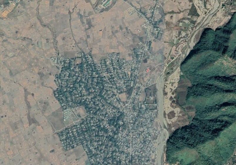
Picture 4 : Present Google Image of ARCHANA and UNBI.
There are 20
edge(corner) in each structure. If we join this 20 edge, the structure can be
drawn.
The coordinates of the 20 edges of ‘Archana’
are given below
1. 24.953379°
93.877710°
2. 24.953383°
93.879519°
3. 24.952518°
93.879495°
4. 24.952520°
93.880351°
5. 24.951875°
93.880415°
6. 24.951792°
93.881405°
7. 24.949891°
93.881268°
8. 24.949888°
93.880396°
9. 24.949141°
93.880316°
10. 24.949157°
93.879353°
11. 24.948389°
93.879321°
12. 24.948471°
93.877450°
13. 24.949231°
93.877428°
14. 24.949304°
93.876490°
15. 24.949944°
93.876562°
16. 24.950118°
93.875646°
17. 24.951752°
93.875717°
18. 24.951654°
93.876716°
19. 24.952359°
93.876762°
20. 24.952406°
93.877782°
The coordinates of the 20 edges of ‘Unbi’
are given below
1.
24.95360° 93.87136°
( Mound, watch tower present
today)
2.
24.953502° 93.873170° ( Mound, watch tower present today)
3.
24.952606° 93.873113°
4.
24.952591° 93.874075°
5.
24.951867° 93.874058°
6.
24.951873°
93.874967°
7.
24.950123°
93.874933°
8.
24.950115°
93.874162°
9.
24.949212°
93.874240°
10. 24.949325°
93.873293°
11. 24.948440°
93.873192°
12. 24.948471° 93.871198°
13. 24.949272°
93.871134°
14. 24.949323° 93.870314°
15. 24.950140° 93.870449°
16. 24.950179° 93.869456°
17. 24.951834° 93.869526°
18. 24.951765° 93.870337°
19. 24.952696°
93.870362°
20. 24.952613°
93.871288°
The layout
as seen from Aerial as well as Satellite images are formed by earth systematically
dumped from the digging of the outer moat along the boundary.
The above are all approximate measurements
and ground measurements using lasers and GPS will be needed for any real
accuracy. The exact shape and size of
the structure can also be known through proper laser guided mapping and survey.

THE STRUCTURE THROUGH THE AGES
During the ensuing
seventy seven years since the aerial reconnaissance images of the location were
taken by Allied Forces, the area has been developed with significant housing
inside ‘Archana’ and ‘Unbi’ . The earthwork and mounds have been levelled for
human accommodation.

Pic 6. Comparison with 1944 and present aerial image

Pic 7: Archana and Unbi December,2010 (
Google Imagery)

LOCAL INTERPRETATION
A
lady residing on the northern edge of ‘Archana’ was interviewed. Her name is Loitongbam Purnimashi aged 70 years. She said,
“The name of the location is called Sekmai Sabal Awang Leikai ”. She further added, there were mounds and
earthworks which were levelled and they found broken earthen pots and charcoals
in the adjoining area.
The author met another local Manipuri who
lives near the northern edge of ‘Unbi’. His
name is Kwairakpam Mani. He is 70 years of age. He said, “This earthwork was
there since time immemorial, it was already there when i was born.” He told us that the name of the locality is
Sekmai Khunou.

Picture 9 : Locals ( Kwairakpam Mani and Loitongbam Purnimashi)
CONCLUSION
It
is very difficult to say when the structures of ‘Archana and Unbi’ were constructed. The Royal Chronicle of
Manipuri Kings, Cheitharol Kumbaba has no mention of the earth work being
constructed. It may be concluded that either the structures were constructed much
before the Manipuri Royal Chronicle started recording the events in Manipur or
it was constructed during the 7 years devastation of 1819-26 by the Burmese
when the Manipuri Royal officials were not aware of the construction.
The presence of water moat around the
boundaries of the structure signifies it was a defensive position or a military
garrison. The exact era when “Archana and Unbi” were constructed can be known
through proper scientific methods and research.
What is certain is that the shape created
by the earth work can only be seen from the air and presumably whoever built this,
would never have seen the beauty of their labours. It is
an interesting and sobering fact that little has been present today of the
beautiful structure and this important archaeological site will be engulfed and
destroyed in few years with human habitation.
A quick and proactive research initiative with a clarion call can record
its presence and significance for posterity.